Displaying 1 - 8 of 8

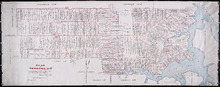
Plan of Township No. 4: Compiled from the plans, leases, deeds, and other documents on file in the…
Description: The map shows Lot 4 divided into parcels of land with the names of residents, their acreage amounts and land conveyance references. The map shows roads in a light brown colour. It shows the P.E.I.… more
Province: Prince Edward Island
Type: cadastral maps
Date Created: 1911-06

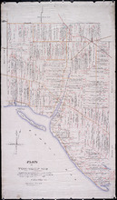
Plan of Township No. 5: compiled from plans, leases, deeds, and other documents on file in the Land…
Description: Plan of Lot 5 compiled from plans, leases, deeds, and other documents on file in the Land Office. The map shows Lot 5 divided into parcels of land with names of residents, their acreage amounts and… more
Province: Prince Edward Island
Type: cadastral maps
Date Created: 1911-09
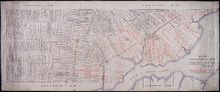
Plan of Township No. 6: Compiled from plans, leases, deeds, and other documents on file in the Land…
Description: The map shows Lot 6 divided into parcels of land with names of residents, their acreage amounts and land conveyance references handwritten in black and red ink. Shows the P.E.I. Railway in red, roads… more
Province: PE
Type: cadastral maps
Date Created: 1912-01
Plan of Township No 14: Compiled from the proprietors' plans and Meacham's Atlas, and…
Description: Plan of Lot 14 compiled from the proprietors' plans and Meacham's Atlas, and from the descriptions in leases and deeds, with additions and corrections from the reports of various surveys on… more
Province: Prince Edward Island
Type: cadastral maps
Date Created: 1914
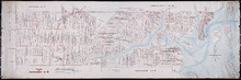
Plan of Township No. 9: compiled from the proprietors' plans and the descriptions in the…
Description: Plan of Lot 9 compiled from the proprietors plans and the descriptions in the leases and deeds, with additions and corrections from the various surveys. The map shows Lot 9 divided into parcels of… more
Province: Prince Edward Island
Type: cadastral maps
Date Created: 1909

Plan of Township No. 6: Compiled from plans, leases, deeds, and other documents on file in the Land…
Description: The map shows Lot 6 divided into parcels of land with names of residents, their acreage amounts and land conveyance references handwritten in black and red ink. Shows the P.E.I. Railway in red, roads… more
Province: Prince Edward Island
Type: cadastral maps
Date Created: 1912-01
Plan of Township No. 5: compiled from plans, leases, deeds, and other documents on file in the Land…
Description: Plan of Lot 5 compiled from plans, leases, deeds, and other documents on file in the Land Office. The map shows Lot 5 divided into parcels of land with names of residents, their acreage amounts and… more
Province: Prince Edward Island
Type: cadastral maps
Date Created: 1911-09

Plan of Township No. 9: compiled from the proprietors' plans and the descriptions in the…
Description: Plan of Lot 9 compiled from the proprietors plans and the descriptions in the leases and deeds, with additions and corrections from the various surveys. The map shows Lot 9 divided into parcels of… more
Province: Prince Edward Island
Type: cadastral maps
Date Created: 1909