Displaying 1 - 3 of 3

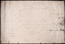
Plan of Lot No 1 Shewing the Extent of the Fishery Reserve to the Crown and situation of settlers…
Description: Plan of Lot 1 (No.6) showing the extent of the Fishery Reserve to the Crown and situation of settlers thereon. Also the site of the respective fishery establishments of the same, as delineated from… more
Province: Prince Edward Island
Type: cadastral maps
Date Created: 1853-10
Office Copy of Plan No. 5 of the Royalty of George Town: by Jos. Ball D. S. Gl. June 7th 1853
Description: The map shows the numbered town lots and street grid of Georgetown. It gives the acreage amounts of a few of the town lots. The names of some residents have been added in pencil. The map shows… more
Province: Prince Edward Island
Type: plans
Date Created: 1853-06-07
Plan Shewing the Situation of Plot No. 94 on Lot or Township No. 15
Description: Plan of part of Lot 15 (No.74). Shows the situation of Plot No.94, the property of John MacInally. 77 acres. MacInally's plot is shaded green. Map also shows Joseph Gallant's Plot No. 93 to… more
Province: Prince Edward Island
Type: cadastral maps