Displaying 1 - 4 of 4
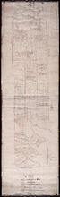
A Plan of Lot or Township No. 43, Comprising the Haviland, Townsend, and Worrell Estates. Compiled…
Description: Plan of Lot 43 (No.116) comprising the Haviland, Townshend, and Worrell Estates. Completed from the surveys of J. Ball and J.C. Underhay by Owen Curtis. Shows names of residents, acreage, and land… more
Province: Prince Edward Island
Type: cadastral maps
Date Created: 1876-08

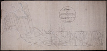
Plan of Lot or Township No. 38: Compiled from the Survey of Jos.h Ball by O. Curtis, Land Office…
Description: Plan of Lot 38 (No.102). Shows names of residents, acreage, and some land conveyance references, bodies of water such as bays, rivers, ponds, gulfs, and harbours, roads, and a nautical compass.
Province: Prince Edward Island
Type: cadastral maps
Date Created: 1876-08
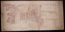
Plan of Lot 32 (No.86).: Cunard Estate.
Description: Plan of Lot 32 (No.86). Cunard Estate. Shows names of residents, acreage, and some land conveyance references, bodies of water such as creeks and rivers, and roads. Copied by Owen Curtis.
Province: Prince Edward Island
Type: cadastral maps
Date Created: 1876-07
Tracing of Plan of A part of the South Moiety of Lot or Township No. 26 in Prince County in the…
Description: Plan of part of the south moiety of Lot 26, including the property of A. E. C. Holland. Plan drawn by John Clay. The map shows part of the southern half of Lot 26 divided into parcels of land with… more
Province: Prince Edward Island
Type: cadastral maps
Date Created: 1876-05-12