Displaying 1 - 4 of 4
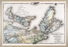
New Atlas of the Dominion of Canada — Counties of Cumberland, Colchester, Pictou, Antigonish,…
Description: The map shows Prince Edward Island and part of Nova Scotia, including all of Cape Breton. The provinces' counties are coloured and labelled in uppercase lettering. A legend explains the symbols… more
Publisher: Meacham Publishing Co.
Province: Nova Scotia, Prince Edward Island
Type: topographic maps
Date Created: 1875 (year approximate)
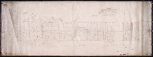
Plan of the North Moriety of a Township No. 26 the Property if the Messrs Thompson of Belfast…
Description: Plan of the North Moiety of Lot 26, the property of the Messrs. Thompson of Belfast Ireland. Shows names of residents, acreage, and a few land conveyance references, bodies of water such as Bedeque… more
Province: Prince Edward Island
Type: cadastral maps
Date Created: 1875-11-05
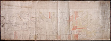
Plan of Lot or Township of No. 13 in Prince County: Prince Edward Island
Description: Plan of Lot 13 (No.35). Yeo Estate. Shows names of residents, acreage, and some land conveyance references. Color code (orange, and yellow) shows willed land and freehold land. The map also shows… more
Province: Prince Edward Island
Type: cadastral maps
Date Created: 1875-10-09
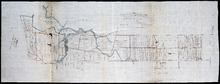
Tracing of Plan of the North Moiety of Township No. 26: The property of the Messrs Thompson of…
Description: Tracing of Plan of the North Moiety of Lot 26, the property of the Messrs. Thompson of Belfast, Ireland. Documents attached. The map shows lots, residents, roads, acreage, and bodies of water.
Province: Prince Edward Island
Type: cadastral maps
Date Created: 1875-11-05