Displaying 1 - 2 of 2
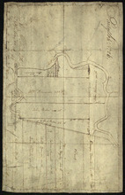
Part of Lot No. 26
Description: Plan of part of Lot 26 (No.3). Plan traced[?] by J. Plaw from a survey by Mr. Major[?]. The maps shows part of Lot 26 (the Centreville area) divided into parcels of land with the names of residents… more
Province: Prince Edward Island
Type: cadastral maps
Date Created: 1810-05-23
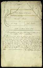
Part of Lot 32: The property of Robert Hodgson
Description: Plan of part of Lot 32 (No.6). The map shows 200 acres of land, outlined in yellow, belonging to Robert Hodgson on the west side of the Prince Town Road in Lot 32. It shows some neighbouring parcels… more
Province: Prince Edward Island
Type: cadastral maps
Date Created: 1810