Displaying 1 - 5 of 5
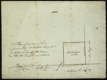
Plan of 500 Acres of Land as fixed on by Mr. Langdon being part of Mrs. Burns Land of 7800 Acres.:…
Description: Plan of part of Lot 38 (No. 5). 500 acres, the property of Mr. Langdon, being part of Mrs. Burns' land of 7800 acres. The maps shows a square parcel of land, 500 acres in size, belonging to Mr.… more
Province: Prince Edward Island
Type: cadastral maps
Date Created: 1809-08
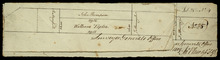
Part of Lot 25
Description: Plan of part of Lot 25 (No.4). Thompson-Taylor land. This item consists of 2 maps——on separate pieces of paper——of the parcels of land belonging to John Thompson (200 acres) and William Taylor (320… more
Province: Prince Edward Island
Type: cadastral maps
Date Created: 1809-11-20
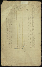
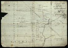
Refugee Lots on Lot 32 Prince Edward Island: Copied from the Original Plan
Description: Plan of Refugee Lots on Lot 32. Copied from the original. The map shows a northern portion of Lot 32 divided into numbered refugee lots, each 100 acres in size. It gives the names of some residents,… more
Province: Prince Edward Island
Type: cadastral maps
Date Created: 1809
Plan of Mrs. Vickersons Land
Description: Plan of part of Lot 34 (No. 4). 74 acres of land. The map shows Barbarey Vickerson's 74-acre parcel of land on the north side of the Hillsborough River in Lot 34. The plan shows roads, including… more
Province: Prince Edward Island
Type: cadastral maps
Date Created: 1809-10-12