Displaying 1 - 6 of 6
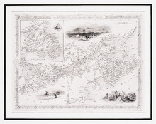
The British Colonies in North America
Description: The map shows New Brunswick, Nova Scotia, Prince Edward Island and parts of Ontario, Quebec and the United States. Newfoundland is shown at the same scale in an inset in the upper left corner. Rivers… more
Publisher: James S. Virtue
Province: New Brunswick, Newfoundland, Nova Scotia, Prince Edward Island, Ontario, Quebec
Type: topographic maps
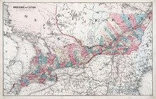
Dominion of Canada: (Western Sheet)
Description: Map showing the province of Ontario, and Quebec. Shows rivers, lakes, channels, bays, roads, railroads, cities, towns, copper mines, and sea measurements. Ontario and Quebec are coloured and cities… more
Publisher: J. H. Meacham & company
Province: Ontario, Quebec, Prince Edward Island, Michigan, New York, Ohio
Type: cadastral maps
Date Issued (Source): 1880
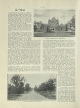
Ontario - 1
Description: Text provides information on the history and farming industries of Ontario
Publisher: Cummins Map Co.
Province: Ontario
Type: text
Date Issued (Source): 1927
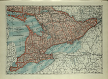
Province of Ontario, Canada
Description: The map shows the Province of Ontario, Canada. Shown are Georgian Bay, Lake Ontario, Erie, and Huron, Michigan, New York, roads, towns and cities.
Publisher: Cummins Map Co.
Province: Ontario
Type: cadastral maps
Date Issued (Source): 1927

Ontario - 2
Description: Text provides information of the farming and other industries of Ontario
Publisher: Cummins Map Co.
Province: Ontario
Type: text
Date Issued (Source): 1927
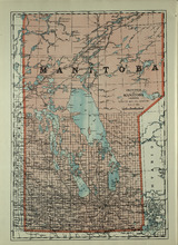
Province of Manitoba, Canada
Description: The map shows the province of Manitoba, Canada. Shown are the lakes, rivers and other bodies of water, and railroads.
Publisher: Cummins Map Co.
Province: Manitoba, Saskatchewan, Ontario
Type: cadastral maps
Date Issued (Source): 1927