Displaying 1 - 9 of 9
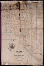
Plan of Township No. 9: Copied from plan furnished by Proprietress with alterations and additions…
Description: Plan of Lot 9 (No.26). Sullivan Estate. Copied from plan furnished by Proprietress with alterations and additions from surveys by Owen Curtis, John Clay &c. Shows names of residents, acreage, and… more
Province: Prince Edward Island
Type: cadastral maps
Date Created: 1883-08-18
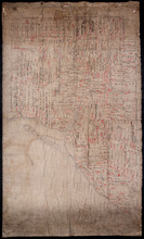
Plan of Township No. 9: compiled from the proprietors' plans and the descriptions in the…
Description: Plan of Lot 9 compiled from the proprietors plans and the descriptions in the leases and deeds, with additions and corrections from the various surveys. The map shows Lot 9 divided into parcels of… more
Province: Prince Edward Island
Type: cadastral maps
Date Created: 1909
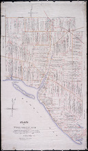
Lot 9
Description: Plan of Lot 9 (No.25). Sullivan Estate. Shows names of residents, acreage, and land conveyance references, rivers, roads, and Sandy or Brae Islands.
Province: Prince Edward Island
Type: cadastral maps
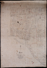
Plan of Township No. 9 in Prince Edward Island: The Property of Miss Charlotte Sullivan containing…
Description: Plan of Lot 9 (No.27). The property of Miss Charlotte Sulivan, containing 17300 acres. Shows names of residents and acreage, bodies of water such as rivers, creeks, roads, Sandy or Brae Island, and… more
Province: Prince Edward Island
Type: cadastral maps

Plan of Township No. 9: compiled from the proprietors' plans and the descriptions in the…
Description: Plan of Lot 9 compiled from the proprietors plans and the descriptions in the leases and deeds, with additions and corrections from the various surveys. The map shows Lot 9 divided into parcels of… more
Province: Prince Edward Island
Type: cadastral maps
Date Created: 1909
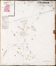
Coleman. P.E.I. Prince Co.: Population. 180. No Protection. Oct 1910.
Description: This is a fire insurance plan of the community of Coleman. It shows the Brae Road in the vicinity of Campbell Road and the P.E.I. Railway. A key plan in the upper left corner provides context. The… more
Publisher: Chas. E. Goad, Civil Engineer
Province: Prince Edward Island
Type: fire insurance maps
Date Created: 1910-10
Date Issued (Source): 1888

Lot No. 9: Prince County
Description: The map shows Lot 9 in Prince county. Shown are roads, Egmont Bay, Dog Cove, roads, and railroads.
Publisher: Cummins Map Co.
Province: Prince Edward Island
Type: cadastral maps
Date Issued (Source): 1927
Rural Directory - Lots 9 and 10, Prince County
Description: A directory listing of residents of lots 9 and 10.
Publisher: Cummins Map Co.
Province: Prince Edward Island
Type: text
Date Issued (Source): 1927

Plan of Lot Nine: Prince Co., P.E.I.
Description: The map shows lot 9 in Prince county. Shown are roads, landowners and acreage, Egmont bay, sand, Brae river, post offices, railroad and station, schools and churches. Compass.
Publisher: J. H. Meacham & company
Province: Prince Edward Island
Type: cadastral maps
Date Issued (Source): 1880