Displaying 1 - 14 of 14
Plan of Lot 32 (No.86).: Cunard Estate.
Description: Plan of Lot 32 (No.86). Cunard Estate. Shows names of residents, acreage, and some land conveyance references, bodies of water such as creeks and rivers, and roads. Copied by Owen Curtis.
Province: Prince Edward Island
Type: cadastral maps
Date Created: 1876-07

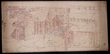
Plan of Township No. 32: compiled from the proprietors plans and Meacham's Atlas and from the…
Description: The map shows Lot 32 divided into parcels of land with names of residents, acreage amounts and land conveyance references. Areas drawn in black indicate government land; areas in red indicate… more
Province: Prince Edward Island
Type: cadastral maps
Date Created: 1919-01
Plan of Township No. 32 situate in the Parish of Charlotte, Queens County, P. E. Island: Scale 20…
Description: Plan of Lot 32 (No.85). One of the plans referred to in the Deed from Sir Edward, William, and Laura Cunard to the Commissioner of Public Lands, July 13, 1866. Shows names of residents, acreage, and… more
Province: Prince Edward Island
Type: cadastral maps
Date Created: 1849
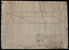
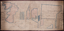
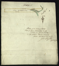
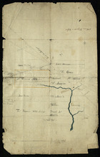
Plan Showing the situation of the Estate of Mr. Clement White on Lot or Township No. 32
Description: Plan of part of Lot 32 (No.21). The estate of Mr. Clement White. The map shows lots, residents, roads, and York (or North) River.
Province: Prince Edward Island
Type: cadastral maps
Date Created: 1874-01

Plan of Township No. 32: compiled from the proprietors plans and Meacham's Atlas and from the…
Description: The map shows Lot 32 divided into parcels of land with names of residents, acreage amounts and land conveyance references. Areas drawn in black indicate government land; areas in red indicate… more
Province: Prince Edward Island
Type: cadastral maps
Date Created: 1919-01

Lot 32
Description: Plan of Lot 32 showing some residents.
Province: Prince Edward Island
Type: cadastral maps
Plan of 100 Acres of Land Part of Lot or Township No. 32.: Situate in Queens County In the Island…
Description: Plan of part of Lot 32 (No.5). 100 acres of land, the property of Alexr. McKenzie. The plan shows 100 acres of land belonging to Alexander McKenzie, outlined in yellow, on the west side of the York (… more
Province: Prince Edward Island
Type: cadastral maps
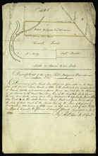
Part of Lot 32: The property of Robert Hodgson
Description: Plan of part of Lot 32 (No.6). The map shows 200 acres of land, outlined in yellow, belonging to Robert Hodgson on the west side of the Prince Town Road in Lot 32. It shows some neighbouring parcels… more
Province: Prince Edward Island
Type: cadastral maps
Date Created: 1810
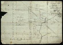
Refugee Lots on Lot 32 Prince Edward Island: Copied from the Original Plan
Description: Plan of Refugee Lots on Lot 32. Copied from the original. The map shows a northern portion of Lot 32 divided into numbered refugee lots, each 100 acres in size. It gives the names of some residents,… more
Province: Prince Edward Island
Type: cadastral maps
Date Created: 1809
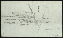
Part of Lot 32: Refugee Lots
Description: Plan of part of Lot 32 (No.4). Refugee Lots. The map shows a northern part of Lot 32 that was divided into refugee lots. It gives the names of residents and acreage amounts for some. The map shows a… more
Province: Prince Edward Island
Type: cadastral maps
Part of Lot 32
Description: Plan of part of Lot 32. North Milton area. The map shows the area around the intersection of the New Glasgow and Rustico roads in the northern part of Lot 32. The land is divided into parcels with… more
Province: Prince Edward Island
Type: cadastral maps
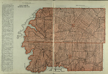
Lots 31 and 32: Queens County
Description: The map shows lots 31 and 32 in Queens county. Shown are rivers, landowners, acreage, roads, and railroads
Publisher: Cummins Map Co.
Province: Prince Edward Island
Type: cadastral maps
Date Issued (Source): 1927
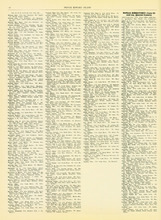
Rural Directory - Lots 31 - 34, Queens County
Description: A directory listing of residents of lots 31, 32, 33, and 34.
Publisher: Cummins Map Co.
Province: Prince Edward Island
Type: text
Date Issued (Source): 1927
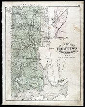
Plan of Lot Thirty Two: Queens Co., P.E.I.
Description: The map shows lot 32 in Queens county. Shown are roads, landowners and acreage, railroad and station, post offices, rivers, churches, and coves. Compass.
Publisher: J. H. Meacham & company
Province: Prince Edward Island
Type: cadastral maps
Date Issued (Source): 1880