Displaying 1 - 4 of 4
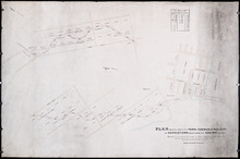
Plan Shewing Lands in the Town, Common, and Royalty of Georgetown appropriated for Railway purposes…
Description: Plan showing lands in the Town, Common, and Royalty of Georgetown appropriated for Railway Purposes. The map shows residents, acreage, roads, and harbours.
Province: Prince Edward Island
Type: cadastral maps

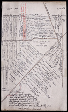
A Plan showing the Position of the Line of Road through, proposes to be run through Lot 47 from…
Description: Plan of existing and proposed road through Lot 47 from George Munn's, West River, to the bridge on the north side of Surveyor's Pond. Distance of 4 miles and 2 chains. Road run under the… more
Province: Prince Edward Island
Type: cadastral maps
Date Created: 1851-08
Plan of an approximate correction of the Junction of the Maitland road with the Murray Harbour Road…
Description: Plan of an approximate correction of the Junction of the Maitland Road with the Murray Harbour Road as sketched in sundry plans by the late Roderick Campbell... and as measured on the ground on the… more
Province: Prince Edward Island
Type: cadastral maps
Date Created: 1921-09-09
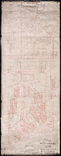
Plan of Lot or Township No. 60 Copied from the Survey of Roderick Campbell by Owen Curtis. L. S.…
Description: Plan of Lot 60 (No.161). Copied from the survey of Roderick Campbell by Owen Curtis, 1877. Shows names of residents, acreage, and land conveyance references. The map shows bodies of water such as… more
Province: Prince Edward Island
Type: cadastral maps
Date Created: 1877