Displaying 784 - 810 of 845
Saskatchewan - 2
Description: Text provides information of population, land, climate, and farming in Saskatchewan
Publisher: Cummins Map Co.
Province: Saskatchewan
Type: text
Date Issued (Source): 1927
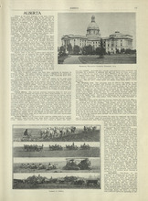
Alberta - 1
Description: Text provides information of different regions of Alberta, their history, and agriculture in Alberta
Publisher: Cummins Map Co.
Province: Alberta
Type: text
Date Issued (Source): 1927
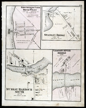
Port Selkirk Farm or Brush Wharf, Stanley Bridge: Murray Harbour South, and Vernon River Bridge
Description: The map shows Port Selkirk Farm or Brush Wharf lot 57 in Queens county. Shown are a river, wharf, road and street, landowners, and measurements. Compass.
Publisher: J. H. Meacham & company
Province: Prince Edward Island
Type: cadastral maps
Date Issued (Source): 1880
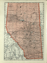
Province of Alberta, Canada
Description: The map shows the province of Alberta, Canada. Shown are bodies of water, rivers, lakes, etc., cities and towns, roads and railroads.
Publisher: Cummins Map Co.
Province: Alberta, British Columbia, Saskatchewan
Type: cadastral maps
Date Issued (Source): 1927
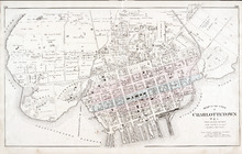
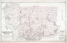
Map of the City of Charlottetown
Description: The map shows the city of Charlottetown. Shown are the wards, roads, landowners and acreage, asylums, ponds, rivers, houses, cemetery, estates, churches, lakes, parks, wharfs, and Charlottetown… more
Publisher: J. H. Meacham & company
Province: Prince Edward Island
Type: cadastral maps
Date Issued (Source): 1880
Alberta - 2
Description: Text provides information of different industries in Alberta, and the population in Alberta
Publisher: Cummins Map Co.
Province: Alberta
Type: text
Date Issued (Source): 1927
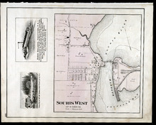
Souris West Lot 44: Kings Co., P.E.I.
Description: The map shows Lot 44 in Souris West, Kings county. Shown are a bay, harbour, river, railroad, landowners, roads, houses and buildings, school houses, businesses, and shipyards. Compass.
Publisher: J. H. Meacham & company
Province: Prince Edward Island
Type: cadastral maps
Date Issued: 1880
Date Issued (Source): 1880
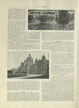
British Columbia - 1
Description: Text provides information of history, climate, lumbering, and agriculture in British Columbia
Publisher: Cummins Map Co.
Province: British Columbia
Type: text
Date Issued (Source): 1927
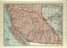
Province of British Columbia, Canada
Description: The map shows the province of British Columbia, Canada. Shown are the Pacific Ocean, Rocky Mountains, Vancouver Island, mountains, roads, and railroads.
Publisher: Cummins Map Co.
Province: British Columbia, Alberta
Type: cadastral maps
Date Issued (Source): 1927
Plan of Charlottetown Royalty: Queens Co., P.E.I.
Description: The map shows the city of Charlottetown and a plan for lots. Shown are rivers, creeks, roads, railroad and stations, landowners and acreage, mills, park, bridge, college, farms, asylums, and a… more
Publisher: J. H. Meacham & company
Province: Prince Edward Island
Type: cadastral maps
Date Issued (Source): 1880
British Columbia - 2
Description: Text provides information of the population and the various industries in British Columbia, such as mining, fishing, manufacturing, and transportation.
Publisher: Cummins Map Co.
Province: British Columbia
Type: text
Date Issued (Source): 1927
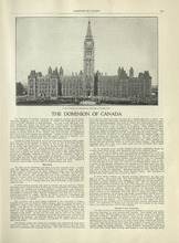
The Dominion of Canada - 1
Description: Text provides information of the history of Canada as a dominion and the establishment of the provinces and territories.
Publisher: Cummins Map Co.
Type: text
Date Issued (Source): 1927
The Dominion of Canada - 2
Description: Text provides information of the physical features of the land dividing each provinces and territories, and the industries that belong to each province and territory
Publisher: Cummins Map Co.
Province: Yukon, Northwest Territories
Type: text
Date Issued (Source): 1927
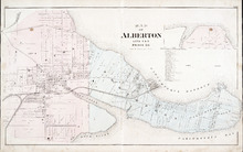
Map of Alberton Lots 4 & 5: Prince Co., P.E.I.
Description: The map shows lots 4 & 5 in the town of Alberton, Prince county. Shown are rivers, creeks, lakes, wharfs, shipyard, roads, railroad, landowners and acreage, mills, churches and cemetery. Compass… more
Publisher: J. H. Meacham & company
Province: Prince Edward Island
Type: cadastral maps
Date Issued (Source): 1880
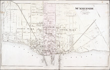
Summerside: Prince Co.
Description: The map shows the city of Summerside. Shown are the wards, roads, landowners and acreage, harbour, barracks, schools, squares, shipyards, railroad and station, and wharfs. Compass.
Publisher: J. H. Meacham & company
Province: Prince Edward Island
Type: cadastral maps
Date Issued (Source): 1880
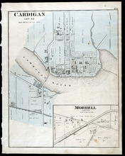
Cardigan Lot 53: Morrell Lot 40
Description: The map shows lot 53 in Cardigan. Shown are a river, roads, railroads, lots, landowners, school house, buildings, houses, wharfs and creeks. Compass.
Publisher: J. H. Meacham & company
Province: Prince Edward Island
Type: cadastral maps
Date Issued (Source): 1880

Montague Bridge Lots 59 & 52: Kings Co., P.E.I.
Description: The map shows lots 59 & 52 in Montague Bridge, Kings county. Shown are rivers, wharfs, shipyards, roads, landowners and acreage, halls, churches, buildings and businesses. Compass.
Publisher: J. H. Meacham & company
Province: Prince Edward Island
Type: cadastral maps
Date Issued (Source): 1880
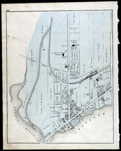
Souris
Description: The map shows a part of Souris. Shown are the Souris river, sand beach, roads, railroads, churhces, landowners, houses, buildings and businesses. Compass
Publisher: J. H. Meacham & company
Province: Prince Edward Island
Type: cadastral maps
Date Issued (Source): 1880
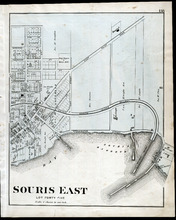
Souris East: Lot Forty Five
Description: The map shows Lot 45 in Souris East. Shown are the Souris Harbour and Bay, wharfs, roads and streets, railroads, lobster factory, landowners, houses, buildings and businesses. Compass
Publisher: J. H. Meacham & company
Province: Prince Edward Island
Type: cadastral maps
Date Issued (Source): 1880
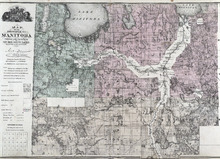
Map of the Province of Manitoba
Description: The map shows the province of Manitoba. Shown on the side are a Reference table and a Township diagram, lakes, roads, marshes, Indian Reserves, churches, rivers, and ponds. Compass.
Publisher: J. H. Meacham & company
Province: Manitoba
Type: cadastral maps
Date Issued (Source): 1880
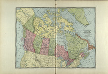
The Dominion of Canada and Newfoundland
Description: The map shows the dominion of Canada and Newfoundland. Shown are all provinces, territories, Greenland, and United States, oceans, bays, and mountains.
Publisher: Cummins Map Co.
Type: cadastral maps
Date Issued (Source): 1927
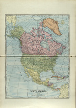
North America
Description: The map shows North America. Shown is the dominion of Canada, United States, Mexico, Central America, bodies of water, and coordinates.
Publisher: Cummins Map Co.
Type: cadastral maps
Date Issued (Source): 1927
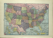
Map of the United States
Description: The map shows the United States. Shown are the Pacific and Atlantic Ocean, dominion of Canada, states, cities and towns.
Publisher: Cummins Map Co.
Type: cadastral maps
Date Issued (Source): 1927
Property Sketches - Page 38
Description: Sketches of locations in Charlottetown and Little York (Lot 34) on Prince Edward Island. Sketches include the residences and property of Hon. W. W. Sullivan, Richard Vessey, Fredk. Hardy, and E. W.… more
Publisher: J. H. Meacham & company
Province: Prince Edward Island
Type: image
Date of Part: 1880
Date Issued (Source): 1880
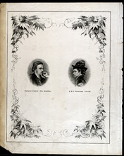
Dedication Page
Description: This page appears after the Table of Contents and contains portraits of the Governor General Marquis of Lorne and Her Royal Highness Princess Louise.
Publisher: J. H. Meacham & company
Province: Prince Edward Island
Type: image
Date Issued (Source): 1880
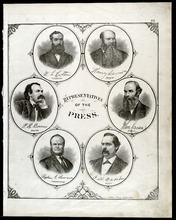
Portraits of Representatives of the Press - Page 22
Description: Sketch of Representatives of the Press including W. L. Cotton (Examiner), Henry Lawson (Patriot), P. R. Bowers (New Era), John Caven (Charlottetown Herald), Rev. Stephen G. Lawson (Presbyterian), and… more
Publisher: J. H. Meacham & company
Province: Prince Edward Island
Type: image
Date Issued (Source): 1880
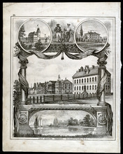
Property Sketches - Page 25
Description: Sketch of various major properties and buildings in Charlottetown, Prince Edward Island including Prince of Wales College, the New Aslyum (Falconwood), Market P.O., Province House, the Court House,… more
Publisher: J. H. Meacham & company
Province: Prince Edward Island
Type: image
Date Issued (Source): 1880