Displaying 1 - 4 of 4

Plan of Lot 39
Description: Plan of Lot 39. Shows names of residents and acreage, bodies of water such as rivers, and bays, and division lines.
Province: Prince Edward Island
Type: cadastral maps
Date Created: 1857-07-01

A Plan of Land on Lot or Township No. 17 in Prince County, P. E. Island
Description: A plan of part of Lot 17, the property of J. Weatherbe, Summerside. (No.11). Shown are lots, residents, measurements and roads.
Province: Prince Edward Island
Type: cadastral maps
Date Created: 1857-06

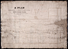
Plan of Lot or Township No. 39: from the lastest Surveys by Joseph Ball, S.G., July 1, 1857
Description: Plan of Lot 39 (No.104). Worrell Estate. Plan copied by Owen Curtis, 1876.
Province: Prince Edward Island
Type: cadastral maps
Date Created: 1857-07-01
Plan of that part of Township Number Forty-nine, in Prince Edward Island, the Property of the Hon.…
Description: Plan of part of Lot 49, the property of the Hon. Edward C. Haythorne and Robert Poore Haythorne. Tracts shaded green sold with the Act 28 Vic. Cap.5. (No.133). Shows names of residents and acreage,… more
Province: Prince Edward Island
Type: cadastral maps
Date Created: 1857-01