Displaying 1 - 4 of 4
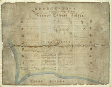
Plan of George-Town: Capital of Kings County, Prince Edward Island
Description: A hand-drawn map of Georgetown, PEI that includes the layout of the town including Kent Square, the ranges, house lots, water lots, and buildings. Three Rivers borders the town.
Province: Prince Edward Island
Date Created: 1835

Plan Shewing the position of the Northern points of Commencement of the Lines dividing Lots 33 and…
Description: The map shows northern portions of Lots 24, 33, 34 and 35 along the north shore of Prince Edward Island. It shows the northern-most sections of three boundary lines: the line dividing Lots 24 and 33… more
Province: Prince Edward Island
Type: chorographic maps
Date Created: 1835-05-07
Plan of the Division Line between Queens and Prince Counties, & the Southern Boundary of…
Description: Plan of the division line between Queens and Prince Counties and the southern boundary of Lot 25, as established by the Commissioners under the Boundary Line Act. (No.81). The map shows the boundary… more
Province: Prince Edward Island
Type: boundary maps
Date Created: 1835
Plan of the Line dividing Kings and Queens Counties in Prince Edward Island as established by the…
Description: Plan of the line dividing Kings and Queens Counties in Prince Edward Island as established by the Commissioners under the provisions of the Act 4th: William 4th: Cap. 15 (No. 80). The map shows the… more
Province: Prince Edward Island
Type: boundary maps
Date Created: 1835