Displaying 1 - 4 of 4
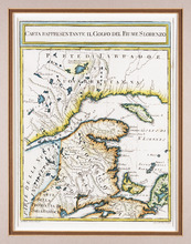
Carta Rappresentante il Golfo del Fiume S. Lorenzo
Description: The map shows the St. Lawrence River/Gulf of St. Lawrence region as far west as the Saguenay River and as far east as Cape Breton. It shows New Brunswick, Prince Edward Island, and parts of Nova… more
Province: New Brunswick, Nova Scotia, Prince Edward Island, Quebec
Type: topographic maps
Date Created: 1765 (year approximate)
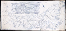
A Plan of the Island St. John in the Gulf of St. Lawrence in the Province of Nova Scotia in North…
Description: Plan of the Island St. John in the Gulf of St. Lawrence in the Province of Nova Scotia in North America from a survey made by Samuel Holland in 1765. Shows statistical data and remarks regarding the… more
Province: Prince Edward Island
Type: cadastral maps
Date Created: 1765

L'ACADIE: Par le Sr. Robert de Vaugindy Fils de Mr. Robert Geogr. ord, du Roy, Avec Privilege
Description: Period designation 18th century. The map shows bodies of water such as Baye Francoise, villages, towns, cities, mountains, trees, islands, and banks.
Province: Nova Scotia, Prince Edward Island
Type: topographic maps
Date Created: Unknown year in the century of the 1700s

Carta Geographica Del Canada Nell' America Settentrionale
Description: Framed map of Canada; cartouche top left corner: natives by a pond with deer and animals which are part dog, part fish. The map shows bodies of water such as Baja D' Hudson, villages, towns, and… more
Type: chorographic maps
Date Created: 1700 to 1799