Displaying 1 - 3 of 3
Carte de l'Accadie et Païs Voisins pour servir a l'Histoire Generale des Voyages: Par M.B…
Description: Rectangular map engraved on paper; framed and covered with glass. Coloured. Depicts Nova Scotia, P.E.I., Cape Breton, and part of New Brunswick; all place names in French. Highland areas in brown.… more
Province: Nova Scotia, New Brunswick, Prince Edward Island
Type: chorographic maps
Date Created: 1757

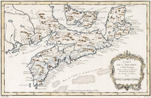
L'ACADIE: Par le Sr. Robert de Vaugindy Fils de Mr. Robert Geogr. ord, du Roy, Avec Privilege
Description: Period designation 18th century. The map shows bodies of water such as Baye Francoise, villages, towns, cities, mountains, trees, islands, and banks.
Province: Nova Scotia, Prince Edward Island
Type: topographic maps
Date Created: Unknown year in the century of the 1700s

Carta Geographica Del Canada Nell' America Settentrionale
Description: Framed map of Canada; cartouche top left corner: natives by a pond with deer and animals which are part dog, part fish. The map shows bodies of water such as Baja D' Hudson, villages, towns, and… more
Type: chorographic maps
Date Created: 1700 to 1799