Displaying 1 - 2 of 2
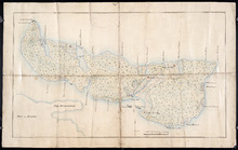
Plan of Île Saint-Jean: The Island of Saint John
Description: Plan of Ile Saint-Jean / the Island of Saint John. The map shows Prince Edward Island and a portion of the mainland. It identifies settlements, bays, harbours, rivers and islands. Sandy areas are… more
Province: Prince Edward Island
Type: topographic maps
Date Created: 1760

L'ACADIE: Par le Sr. Robert de Vaugindy Fils de Mr. Robert Geogr. ord, du Roy, Avec Privilege
Description: Period designation 18th century. The map shows bodies of water such as Baye Francoise, villages, towns, cities, mountains, trees, islands, and banks.
Province: Nova Scotia, Prince Edward Island
Type: topographic maps
Date Created: Unknown year in the century of the 1700s