Displaying 1 - 4 of 4
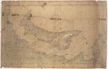
North America Dominion of Canada Gulf St. Lawrence Prince Edward Island: and Adjacent Coasts from…
Description: Prince Edward Island and adjacent coasts from Sea Wolf Island to Escuminac Point. Date of plan: April, 1888, corrected to 31 May, 1901.
Publisher: U.S. Navy Hydrographic Office
Province: Prince Edward Island
Type: nautical charts
Date Created: 1901
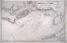
Hillsborough Bay
Description: Paper map in frame. Nautical chart originally published in 1842 and corrected and reissued many times. Large corrections in 1860, 1868, 1869, 1881. Relief is described pictorially, with hachures,… more
Publisher: Office of the Admiralty
Province: Prince Edward Island
Type: nautical charts
Date Issued: 1929
Date Created: 1842
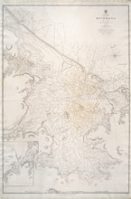
Richmond Bay: 1845
Description: Paper map in frame. Nautical chart originally published in 1845. Relief is described pictorially, with hachures, stippling and soundings. Bays, capes, heads, harbours, islands, lakes, ports, points,… more
Publisher: Hydrographic Office of the Admiralty
Province: Prince Edward Island
Type: nautical charts
Date Issued: 1850
Date Created: 1845
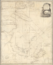
A New Chart of the Gulf of St. Lawrence Compiled from the Original Drawings of Actual Surveys
Description: The most accurate chart of the Gulf of St. Lawrence in 1790, especially its depiction of Cape Breton Island. "The Most Detailed Chart of the St. Lawrence River to Date Fine example of Thomas… more
Publisher: William Faden
Province: Prince Edward Island, Nova Scotia, New Brunswick, Quebec
Type: nautical charts
Date Created: 1790