Displaying 1 - 6 of 6
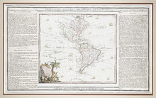
L'Amérique Dressée pour l'étude de la Géographie,: revue et augmentée par Mr. Brion,…
Description: This is a map of the Americas with the northwestern part of North America left undefined. It shows more large lakes to the west of the Great Lakes and a river route to the Pacific, which was believed… more
Type: chorographic maps
Date Created: 1786
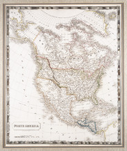
North America: By Sidney Hall.
Description: Framed map of North America. The map shows North America and parts of South America, Greenland and Russia (including the territory that is now Alaska). Part of present-day British Columbia, including… more
Publisher: Longman, Rees, Orme, Brown & Green
Type: chorographic maps
Date Created: 1829-08-01

Plan Shewing the position of the Northern points of Commencement of the Lines dividing Lots 33 and…
Description: The map shows northern portions of Lots 24, 33, 34 and 35 along the north shore of Prince Edward Island. It shows the northern-most sections of three boundary lines: the line dividing Lots 24 and 33… more
Province: Prince Edward Island
Type: chorographic maps
Date Created: 1835-05-07
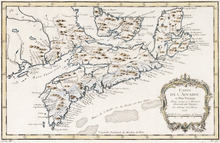
Carte de l'Accadie et Païs Voisins pour servir a l'Histoire Generale des Voyages: Par M.B…
Description: Rectangular map engraved on paper; framed and covered with glass. Coloured. Depicts Nova Scotia, P.E.I., Cape Breton, and part of New Brunswick; all place names in French. Highland areas in brown.… more
Province: Nova Scotia, New Brunswick, Prince Edward Island
Type: chorographic maps
Date Created: 1757
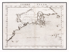
Tierra Nueva
Description: Rectangular black and white engraved map on paper; framed under glass. Map depicts eastern part of Canada including Cape Breton and Newfoundland. Shape rectangular Additional associations Frame HF.94… more
Type: chorographic maps
Date Created: 1561

Carta Geographica Del Canada Nell' America Settentrionale
Description: Framed map of Canada; cartouche top left corner: natives by a pond with deer and animals which are part dog, part fish. The map shows bodies of water such as Baja D' Hudson, villages, towns, and… more
Type: chorographic maps
Date Created: 1700 to 1799