Displaying 1 - 3 of 3

Plan of Township No. 48: compiled during the year 1915 from plans on file in the Land Office and…
Description: Plan of Lot 48 compiled during the year 1915 from plans on file in the Land Office and Registry Office and from the chart of Charlottetown Harbour supplemented by the descriptions in the leases and… more
Province: Prince Edward Island
Type: cadastral maps
Date Created: 1915
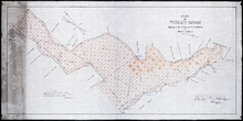
Plan of Foxley River: Showing Subdivisions to be leased for Oyster Culture
Description: Plan of Foxley River showing subdivisions to be leased for Oyster Culture. (No.17). The map shows residents, lots, and measurements.
Province: Prince Edward Island
Type: cadastral maps
Date Created: 1915
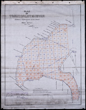
Plan of Trout or Lot 10 River: showing subdivisions to be leased for Oyster Culture
Description: Plan of Trout or Lot 10 River showing subdivisions to be leased for Oyster Culture. (No.18). The map shows redisents, measurements, and a certificate of registration.
Province: Prince Edward Island
Type: cadastral maps
Date Created: 1915