Displaying 1 - 7 of 7
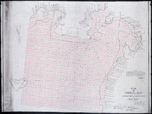
Plan of Pownal Bay: showing the subdivisions to be leased for Oyster Culture
Description: Plan of Pownal Bay showing the subdivisions to be leased for Oyster Culture. (No.13) The map shows residents, lots, measurements, and islands.
Province: Prince Edward Island
Type: cadastral maps
Date Created: 1914
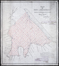
Plan of New London Bay: Showing Sub-divisions to be leased for Oyster Culture
Description: Plan of New London Bay showing sub-divisions to be leased for Oyster Culture. (No.9) The map shows residents, lots, measurements, and sand hills.
Province: Prince Edward Island
Type: cadastral maps
Date Created: 1914
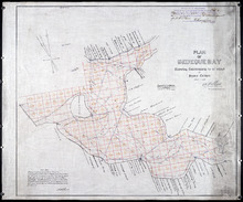
Plan of Bedeque Bay : Showing Sub-divisions to be leased for Oyster Culture
Description: Plan of Bedeque Bay showing sub-divisions to be leased for Oyster Culture. (No.16) The map shows residents, lots, measurements, and Holman's Island. more
Province: Prince Edward Island
Type: cadastral maps
Date Created: 1914-06-01
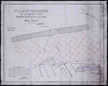
Plan of Narrows at Cranberry Point: showing subdivisions to be leased for Oyster Culture
Description: Plan of Narrows at Cranberry Point (between Cascumpeque and Richmond Bays) showing subdivisions to be leased for Oyster Culture. (No.15). The map shows residents, measurements, sand hills, and a… more
Province: Prince Edward Island
Type: cadastral maps
Date Created: 1914-09-01
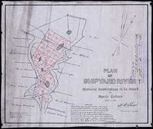
Plan of Shipyard River: showing subdivisions to be leased for Oyster Culture
Description: Plan of Shipyard River showing subdivisions to be leased for Oyster Culture. (No.11). The map shows lots, residents, and measurements, along with a certificate of registration.
Province: Prince Edward Island
Type: cadastral maps
Date Created: 1914
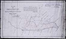
Plan of Indian River: showing subdivisions to be leased for Oyster Culture
Description: Plan of Indian River showing subdivisions to be leased for Oyster Culture. (No.12). The map shows lots, and residents namesm along with measurements of the lots to be leased. Also shown is a… more
Province: Prince Edward Island
Type: cadastral maps
Date Created: 1914
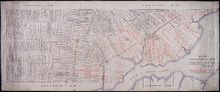
Plan of Township No 14: Compiled from the proprietors' plans and Meacham's Atlas, and…
Description: Plan of Lot 14 compiled from the proprietors' plans and Meacham's Atlas, and from the descriptions in leases and deeds, with additions and corrections from the reports of various surveys on… more
Province: Prince Edward Island
Type: cadastral maps
Date Created: 1914