Displaying 1 - 7 of 7

Plan of Cascumpec Bay: Showing Sub-divisions to be leased for Oyster Culture
Description: Plan of Cascumpec Bay showing sub-divisions to be leased for Oyster Culture. (No.8) The map shows residents, measurements, lots, rivers, and sand hills.
Province: Prince Edward Island
Type: cadastral maps
Date Created: 1913-11-17

Plan of North River from Victoria Park to North River Bridge: Showing Subdivisions to be leased for…
Description: Plan of North River from Victoria Park to North River Bridge showing subdivisions to be leased for Oyster Culture. (No.5) The map shows residents, lots, measurements, and roads.
Province: Prince Edward Island
Type: cadastral maps
Date Created: 1913-02-15

Plan of Barbara Weit River: Showing Subdivisions to be leased for Oyster Culture.
Description: Plan of Barbara Weit River showing subdivisions to be leased for Oyster Culture. (No.7) The map shows residents, lots, Richmond Bay and measurements.
Province: Prince Edward Island
Type: cadastral maps
Date Created: 1913-09-06

Plan of Dockriver: Showing Subdivisions to be leased for Oyster Culture.
Description: Plan of Dock River showing subdivisions to be leased for Oyster Culture. (No.14). The map shows residents, measurements, bays and Fox Island.
Province: Prince Edward Island
Type: cadastral maps
Date Created: 1913-11-17
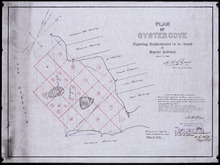
Plan of Oyster Cove: showing subdivisions to be leased for Oyster Culture
Description: Plan of Oyster Cove showing subdivisions to be leased for Oyster Culture. (No.6). The map shows redisents, measurements, and Richmond Bay.
Province: Prince Edward Island
Type: cadastral maps
Date Created: 1913-08-15
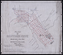
Plan of Bentinck Cove: Showing location of Oyster Beds and subdivisions for leasing purposes/
Description: Plan of Bentinck Cove showing location of Oyster Beds and subdivisions for leasing purposes. (No.4) The map shows lots, residents, and measurements of those lots.
Province: Prince Edward Island
Type: cadastral maps
Date Created: 1913-03-20

Plan of Building Lots in Common Lots Nos. 28 and 29 (Palmer Estate)
Description: Plan of building lots in Common Lots No.28 and No.29. The Palmer Estate. The map also shows streets such as Euston, Orlebar, lot numbers and acreage.
Province: Prince Edward Island
Type: cadastral maps
Date Created: 1913