Displaying 1 - 8 of 8
Plan of Webber Creek: being supplementary to "Plan of Richmond Bay from Curtain Island to…
Description: Plan of Webber Creek being supplementary to "Plan of Richmond Bay from Curtain Island to Lockes Shore" showing additional plots Nos. 478B, 478C, 478D, and 478E for Oyster Culture. The map… more
Province: Prince Edward Island
Type: plans
Date Created: 1913-10-08

Plan of Cascumpec Bay: Showing Sub-divisions to be leased for Oyster Culture
Description: Plan of Cascumpec Bay showing sub-divisions to be leased for Oyster Culture. (No.8) The map shows residents, measurements, lots, rivers, and sand hills.
Province: Prince Edward Island
Type: cadastral maps
Date Created: 1913-11-17

Plan of North River from Victoria Park to North River Bridge: Showing Subdivisions to be leased for…
Description: Plan of North River from Victoria Park to North River Bridge showing subdivisions to be leased for Oyster Culture. (No.5) The map shows residents, lots, measurements, and roads.
Province: Prince Edward Island
Type: cadastral maps
Date Created: 1913-02-15

Plan of Barbara Weit River: Showing Subdivisions to be leased for Oyster Culture.
Description: Plan of Barbara Weit River showing subdivisions to be leased for Oyster Culture. (No.7) The map shows residents, lots, Richmond Bay and measurements.
Province: Prince Edward Island
Type: cadastral maps
Date Created: 1913-09-06

Plan of Dockriver: Showing Subdivisions to be leased for Oyster Culture.
Description: Plan of Dock River showing subdivisions to be leased for Oyster Culture. (No.14). The map shows residents, measurements, bays and Fox Island.
Province: Prince Edward Island
Type: cadastral maps
Date Created: 1913-11-17
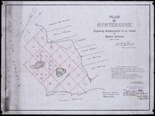
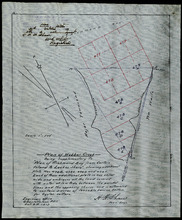
Plan of Oyster Cove: showing subdivisions to be leased for Oyster Culture
Description: Plan of Oyster Cove showing subdivisions to be leased for Oyster Culture. (No.6). The map shows redisents, measurements, and Richmond Bay.
Province: Prince Edward Island
Type: cadastral maps
Date Created: 1913-08-15
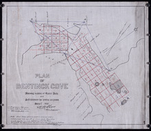
Plan of Bentinck Cove: Showing location of Oyster Beds and subdivisions for leasing purposes/
Description: Plan of Bentinck Cove showing location of Oyster Beds and subdivisions for leasing purposes. (No.4) The map shows lots, residents, and measurements of those lots.
Province: Prince Edward Island
Type: cadastral maps
Date Created: 1913-03-20

Plan of Building Lots in Common Lots Nos. 28 and 29 (Palmer Estate)
Description: Plan of building lots in Common Lots No.28 and No.29. The Palmer Estate. The map also shows streets such as Euston, Orlebar, lot numbers and acreage.
Province: Prince Edward Island
Type: cadastral maps
Date Created: 1913