Displaying 1 - 3 of 3
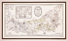
Prince Edward Island, divided into Counties & Parishes, with the Lots, as Granted by Government…
Description: Framed map of the province of Prince Edward Island. As the title indicates, the map shows Prince Edward Island divided into counties (shown in blue, yellow and pink), parishes and the Holland lots.… more
Publisher: Ashby, H.
Province: Prince Edward Island
Type: topographic maps
Date Created: 1798
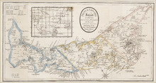
Prince Edward Island: divided into Counties & Parishes, with the Lots, as Granted by Government…
Description: Prince Edward Island divided into Counties and Parishes with the Lots as granted by Government, exhibiting all the New Settlements, Roads, Mills, etc. Published by H. Ashby, King Street, Cheapside,… more
Publisher: Ashby, H.
Province: Prince Edward Island
Type: cadastral maps
Date Created: 1798-03-01

L'ACADIE: Par le Sr. Robert de Vaugindy Fils de Mr. Robert Geogr. ord, du Roy, Avec Privilege
Description: Period designation 18th century. The map shows bodies of water such as Baye Francoise, villages, towns, cities, mountains, trees, islands, and banks.
Province: Nova Scotia, Prince Edward Island
Type: topographic maps
Date Created: Unknown year in the century of the 1700s