Displaying 1 - 5 of 5
Plan of Railway appropriations in Lots 26, 27 and 28
Description: Plan of Railway appropriations in Lots 26, 27 and 28. The map shows lots, roads, residents, and acreage.
Province: Prince Edward Island
Type: cadastral maps, transportation maps

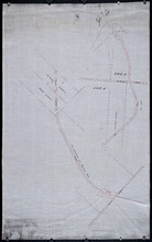
Plan of Part of the Railway Line on Lots No 17.
Description: Plan of part of the Railway Line on Lot 17. Appropriations from the French Purchase to the Linkletter Road. The map shows roads, residents and acreage.
Province: Prince Edward Island
Type: cadastral maps, transportation maps
Date Created: 1872-04-29
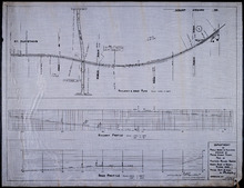
Plan of Proposed Railway Crossing North River to Mount Edward Roads
Description: Plan of proposed Railway crossing North River to Mount Edward Road. Department of Public Works and Highways, Province of Prince Edward Island. Plan shows 3 drawings consisting of the Railway &… more
Province: Prince Edward Island
Type: cadastral maps, transportation maps
Date Created: 1949
Plan of part of the Railway appropriation in Lots 5 and 6
Description: Plan of part of the Railway appropriation in Lots 5 and 6. Shown are lots, roads, and residents.
Province: Prince Edward Island
Type: cadastral maps, transportation maps
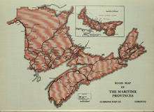
Road Map of the Maritime Provinces
Description: The map shows the Provinces of Prince Edward Island, New Brunswick, Nova Scotia, and Cape Breton Island. Also shown are cities and towns and a Reference table that shows different road conditions.
Publisher: Cummins Map Co.
Province: Prince Edward Island, New Brunswick, Nova Scotia, Cape Breton Island
Type: transportation maps
Date Issued (Source): 1927