Displaying 1 - 2 of 2

Plan Shewing the position of the Northern points of Commencement of the Lines dividing Lots 33 and…
Description: The map shows northern portions of Lots 24, 33, 34 and 35 along the north shore of Prince Edward Island. It shows the northern-most sections of three boundary lines: the line dividing Lots 24 and 33… more
Province: Prince Edward Island
Type: chorographic maps
Date Created: 1835-05-07
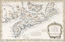
Carte de l'Accadie et Païs Voisins pour servir a l'Histoire Generale des Voyages: Par M.B…
Description: Rectangular map engraved on paper; framed and covered with glass. Coloured. Depicts Nova Scotia, P.E.I., Cape Breton, and part of New Brunswick; all place names in French. Highland areas in brown.… more
Province: Nova Scotia, New Brunswick, Prince Edward Island
Type: chorographic maps
Date Created: 1757