Displaying 28 - 44 of 44
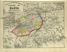
County of Hants: Nova Scotia
Description: The map shows the county of Hants in Nova Scotia. Shown are basins, lakes, gold mines, railroads, stations, and rivers.
Publisher: Roe Brothers
Province: Nova Scotia
Type: geological maps
Date Issued (Source): 1878
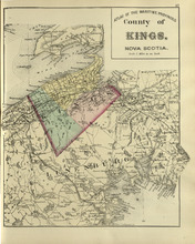
County of Kings: Nova Scotia
Description: The map shows the county of Kings in Nova Scotia. Shown are bays, brooks, creeks, lakes, railroads and stations, mines, roads, cities and towns.
Publisher: Roe Brothers
Province: Nova Scotia
Type: geological maps
Date Issued (Source): 1878
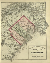
County of Lunenburg: Nova Scotia
Description: The map shows the county of Lunenburg in Nova Scotia. Shown are railroads abd stations, roads, rivers, bays, coves, basins, lakes, and harbours.
Publisher: Roe Brothers
Province: Nova Scotia
Type: geological maps
Date Issued (Source): 1878
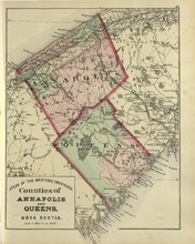
Coutnies of Annapolis and Queens : Nova Scotia
Description: The map shows the counties of Annapolis and Queens in Nova Scotia. Shown are rivers, roads, railroads, stations, lakes, harbours, cities, and towns.
Publisher: Roe Brothers
Province: Nova Scotia
Type: geological maps
Date Issued (Source): 1878
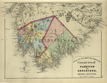
Counties of Yarmouth and Shelburne: Nova Scotia
Description: The map shows the counties of Yarmouth and Shelburne in Nova Scotia. Shown are railroads, stations, capes, coves, rivers, lakes, and harbours.
Publisher: Roe Brothers
Province: Nova Scotia
Type: geological maps
Date Issued (Source): 1878
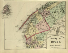
County of Digby: Nova Scotia
Description: The map shows the county of Digby in Nova Scotia. Shown are coves, rivers, capes, lakes, roads, railroads, bridges, cities and towns.
Publisher: Roe Brothers
Province: Nova Scotia
Type: geological maps
Date Issued (Source): 1878
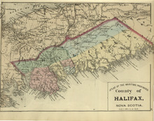
County of Halifax: Nova Scotia
Description: The map shows the county of Halifax in Nova Scotia. Shown are harbours, rivers, lakes, bays, gold mines, towns, and cities.
Publisher: Roe Brothers
Province: Nova Scotia
Type: geological maps
Date Issued (Source): 1878
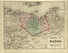
County of Pictou: Nova Scotia
Description: The map shows the county of Pictou in Nova Scotia. Shown are channel, rivers, lakes, harbours, railroads, lakes, mills, towns, and cities.
Publisher: Roe Brothers
Province: Nova Scotia
Type: geological maps
Date Issued (Source): 1878
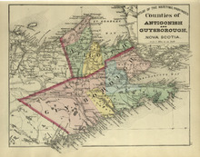
Couties of Antigonish and Guysborough: Nova Scotia
Description: The map shows the counties of Antigonish and Guysborough in Nova Scotia. Shown are rivers, bays, capes, lakes, points, roads, railroads, coves, harbours, cities, and towns.
Publisher: Roe Brothers
Province: Nova Scotia
Type: geological maps
Date Issued (Source): 1878
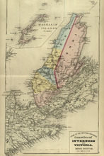
Counties of Inverness and Victoria: Nova Scotia
Description: The map shows the counties of Inverness and Victoria in Nova Scotia. Shown are bays, lakes, rivers, coves, gold mines, islands, harbours, cities, and towns.
Publisher: Roe Brothers
Province: Nova Scotia
Type: geological maps
Date Issued (Source): 1878
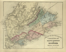
Counties of Cape Breton and Richmond: Nova Scotia>
Description: The map shows the counties of Cape Breton and Richmond in Nova Scotia. Shown are bays, lakes, points, channels, harbours, roads, railroads, towns, and cities.
Publisher: Roe Brothers
Province: Nova Scotia
Type: geological maps
Date Issued (Source): 1878
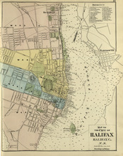
Map of the City of Halifax: Halifax Co. N.S.
Description: The map shows the city of Halifax, Halifax County in Nova Scotia. Shown are a Reference table, Halifax Harbour, pond, roads, wards, lots, buildings, and landowners.
Publisher: Roe Brothers
Province: Nova Scotia
Type: geographical maps
Date Issued (Source): 1878
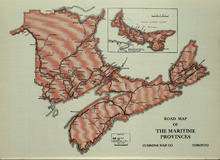
Road Map of the Maritime Provinces
Description: The map shows the Provinces of Prince Edward Island, New Brunswick, Nova Scotia, and Cape Breton Island. Also shown are cities and towns and a Reference table that shows different road conditions.
Publisher: Cummins Map Co.
Province: Prince Edward Island, New Brunswick, Nova Scotia, Cape Breton Island
Type: transportation maps
Date Issued (Source): 1927
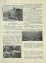
Nova Scotia - 1
Description: Text provides information of the history and industries in Nova Scotia
Publisher: Cummins Map Co.
Province: Nova Scotia
Type: text
Date Issued (Source): 1927
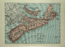
Province of Novia Scotia and Prince Edward Island Canada
Description: The map shows the Provinces of Novia Scotia and Prince Edward Island Canada. Shown are Cape Breton Island, New Brunswick, Atlantic Ocean, Sable Island, Northumberland Strait, Bay of Fundy, roads,… more
Publisher: Cummins Map Co.
Province: Nova Scotia, Prince Edward Island, Cape Breton Island, New Brunswick
Type: cadastral maps
Date Issued (Source): 1927
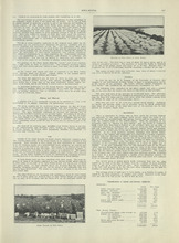
Nova Scotia - 2
Description: Text provides information of the different industries of Nova Scotia such as mining, coal, foresty and agriculture
Publisher: Cummins Map Co.
Province: Nova Scotia
Type: text
Date Issued (Source): 1927
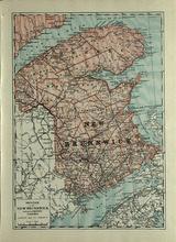
Province of New Brunswick and part of Quebec, Canada
Description: The map shows the Provinces of New Brunswick and part of Quebec, Canada. Shown are Prince Edward Island, United States, Nova Scotia, St. Lawrence River and Gulf, Northumberland Strait, Bay of Fundy,… more
Publisher: Cummins Map Co.
Province: Nova Scotia, Prince Edward Island, Quebec, New Brunswick
Type: cadastral maps
Date Issued (Source): 1927