Displaying 1 - 3 of 3
L'Amérique Dressée pour l'étude de la Géographie,: revue et augmentée par Mr. Brion,…
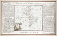
Description: This is a map of the Americas with the northwestern part of North America left undefined. It shows more large lakes to the west of the Great Lakes and a river route to the Pacific, which was believed… more
Type: chorographic maps
Date Created: 1786

L'ACADIE: Par le Sr. Robert de Vaugindy Fils de Mr. Robert Geogr. ord, du Roy, Avec Privilege
Description: Period designation 18th century. The map shows bodies of water such as Baye Francoise, villages, towns, cities, mountains, trees, islands, and banks.
Province: Nova Scotia, Prince Edward Island
Type: topographic maps
Date Created: Unknown year in the century of the 1700s

Carta Geographica Del Canada Nell' America Settentrionale
Description: Framed map of Canada; cartouche top left corner: natives by a pond with deer and animals which are part dog, part fish. The map shows bodies of water such as Baja D' Hudson, villages, towns, and… more
Type: chorographic maps
Date Created: 1700 to 1799