Displaying 1 - 6 of 6

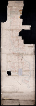
Plan of that part of Lot or Township No. 55, lying North: lying North of Boughton River shewing the…
Description: Plan of that part of Lot or Township 55 lying north of Boughton River showing the situation of the respective plots as coloured green which are still in the Crown. The map shows bodies of water such… more
Province: Prince Edward Island
Type: cadastral maps
Date Created: 1845

Plan of Township No. 55: Compiled from the plans on file in the Land and Registry Offices, from the…
Description: Plan of Lot 55 compiled from the plans on file in the Land and Registry Offices, from the descriptions in the registered Grants and from Meacham's Atlas. Shows names of residents, acreage, and… more
Province: Prince Edward Island
Type: cadastral maps
Date Created: 1919
Plan of Township No. 55: From various Surveys made between the Years 1818 and 1845
Description: The map is a Plan of Township No. 55. The mqp shows bodies of water such as the Cardigan River, and Boughton River, lots, landowers, acreage, and Boughton Island.
Province: Prince Edward Island
Type: cadastral maps
Date Created: 1848-03-21
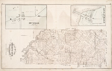
Plan of Lot Thirty One: Queens Co., P.E.I.
Description: The map shows lot 31 in Queens county. Shown are rivers, landowners and acreage, post offices, creeks, railroads and stations, roads, churches, a ferry, and school houses. Compass. Illustrated… more
Publisher: J. H. Meacham & company
Province: Prince Edward Island
Type: cadastral maps
Date Issued (Source): 1880
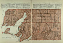
Lots 55 and 56: Kings County
Description: The map shows lots 55 and 56 in Kings county. Shown are bays, rivers, ponds, landowners, acreage, roads, coves, and Boughton Island.
Publisher: Cummins Map Co.
Province: Prince Edward Island
Type: cadastral maps
Date Issued (Source): 1927
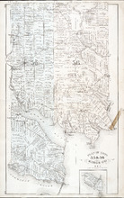
Plan of Lots 55 & 56: Kings Co., P.E.I.
Description: The map shows lots 55 & 56 in Kings county. Shown are roads, landowners and acreage, crosses, rivers, ponds, creeks, bays, coves, sand, wharfs, mills, post offices, churches, schools, and… more
Publisher: J. H. Meacham & company
Province: Prince Edward Island
Type: cadastral maps
Date Issued (Source): 1880