Displaying 1 - 4 of 4

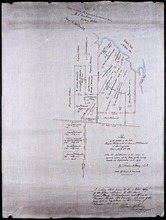
Plan of Lot 39
Description: Plan of Lot 39. Shows names of residents and acreage, bodies of water such as rivers, and bays, and division lines.
Province: Prince Edward Island
Type: cadastral maps
Date Created: 1857-07-01
Plan of the estates of the late Angus McDonald and James McDonald at Springfield Township No 39:…
Description: Part of Lot 39. Plan of the estates of the late Angus McDonald and James McDonald at Springfield. Also the subdivisions of the same as agreed upon at the time of survey. The map shows lots, residents… more
Province: Prince Edward Island
Type: cadastral maps
Date Created: 1910-09

Plan of Lot or Township No. 39: from the lastest Surveys by Joseph Ball, S.G., July 1, 1857
Description: Plan of Lot 39 (No.104). Worrell Estate. Plan copied by Owen Curtis, 1876.
Province: Prince Edward Island
Type: cadastral maps
Date Created: 1857-07-01
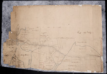
Plan of Lot No. 38 [? title partly missing]
Description: Plan of part of Lot 38 and part of Lot 39. Savage Harbour area. The map shows northern portions of Lot 38 and Lot 39 divided into parcels of land with names of residents and acreage amounts. It shows… more
Province: Prince Edward Island
Type: cadastral maps