Displaying 1 - 11 of 11
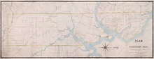
Plan of Township No. 21 and its connexions with adjoining Townships.: Compiled from Surveys by H.J…
Description: Plan of Lot 21 and its connections with adjoining Townships. Shows the names of a few residents north of the South West River. The map also shows many other rivers and creeks, roads, and a nautical… more
Province: Prince Edward Island
Type: cadastral maps
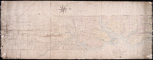
Plan of Township No. 24 Situate in Grenville Parish. Queen's County. P.E.Island.: Complied…
Description: Plan of Lot 21 situate in Grenville Parish (No.54). Compiled from actual surveys. Cunard Estate. Shows names of residents and acreage, bodies of water such as gulfs, rivers, and creeks, roads, and a… more
Province: Prince Edward Island
Type: cadastral maps
Date Created: 1844
Plan of Lot Twenty One : Queens Co P.E.I.
Description: Plan of Lot 21 drawn from old maps, plans, and records. Shows names of residents, acreage, and land conveyance references, bodies of water such as bays, ponds, gulfs, and rivers, roads, and a… more
Province: Prince Edward Island
Type: cadastral maps
Date Created: 1952
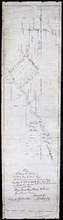
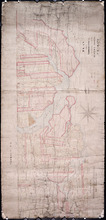
Plan showing the position of 2 new lines of road from R. McMillan's Mills to Fredericton…
Description: Plan showing the position of 2 new lines of road from R. McMillan's Mills to Fredericton Station. Also through McMillan's land from French Settlement. Also from Trout River Bridge to Road… more
Province: Prince Edward Island
Type: cadastral maps
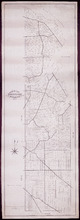
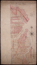
Plan of part of Lot 21: No. 55
Description: The map shows the southern portion of Lot 21 divided into parcels of land with the names of resident and their acreage amounts. Some parcels are outlined in red. Land conveyance information appears… more
Province: Prince Edward Island
Type: cadastral maps
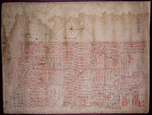
Plan of part of Township No. 21 Grenville Parish, Queens County P.E.Island: H.J. Cundall delt 1850
Description: Plan of the northern part of Lot 21 (No.56). Cunard Estate. One of the plans referred to in the deed from Sir Edward, William, and Laura Cunard to the Commissioner of Public Land, July 13, 1866.… more
Province: Prince Edward Island
Type: cadastral maps
Date Created: 1850
Plan of part of Township No. 21: Copied from a Plan of H,J, Cundall's
Description: Plan of the northern part of Lot 21 (No.57). Cunard Estate. Shows names of residents, acreage, and some land conveyance references, bodies of water such as rivers, and the Gulf of Saint Lawrence,… more
Province: Prince Edward Island
Type: cadastral maps
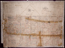
Part of Township No. 21: in Prince Edward Island
Description: Plan of the southern half of Lot 21. One of the plans referred to in the Deed from Sir Edward, William and Laura Cunard to the Commissioner of Public Land, July 13, 1866. Shows names of residents,… more
Province: Prince Edward Island
Type: cadastral maps

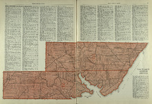
Plan of Lot Twenty One & Twenty: Queens Co., P.E.I.
Description: The map shows lots 21 and 20 (coloured in pink) in Queens county that border Prince county. The map names roads, landowners and acreage, creeks, gulfs, rivers, coves, fishing stations, post offices,… more
Publisher: J. H. Meacham & company
Province: Prince Edward Island
Type: cadastral maps
Date Issued (Source): 1880
Lot 20 and 21: Queens County
Description: The map shows lots 20 and 21 in Queens county. Shown are the Gulf of St. Lawrence, New London River and Bay, capes, ponds, rivers, landowners, acreage, and roads.
Publisher: Cummins Map Co.
Province: Prince Edward Island
Type: cadastral maps
Date Issued (Source): 1927
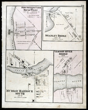
Port Selkirk Farm or Brush Wharf, Stanley Bridge: Murray Harbour South, and Vernon River Bridge
Description: The map shows Port Selkirk Farm or Brush Wharf lot 57 in Queens county. Shown are a river, wharf, road and street, landowners, and measurements. Compass.
Publisher: J. H. Meacham & company
Province: Prince Edward Island
Type: cadastral maps
Date Issued (Source): 1880