Displaying 1 - 4 of 4
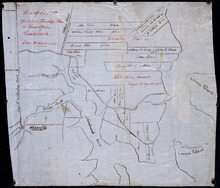
Part of Lot 12 : copied from Township Plan in Land Office Charlottetown
Description: Plan of part of Lot 12 - North Shore. Shows names of some residents, acreage, roads, creeks, Islands, towns and cities. Copied from Township Plan in the Land Office at Charlottetown.
Province: Prince Edward Island
Type: cadastral maps
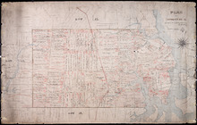
Plan of part of The Western Road.: W. Curtis
Description: (No. 46). The map shows a plan of the Western Road from St. Eleanor's to Lot 10. The road passes through Lots 10, 11, 12, 13, 14, 16 and 17. The map shows part of the Ellis River and other… more
Province: Prince Edward Island
Type: plans
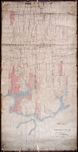
Plan of Township No. 12: Copied from Survey by John Ball L.S. by Thos Mackinlay
Description: Plan of Lot 12 (No.34). Stewart Estate. Copied from survey of John Ball by Thos. MacKinlay. Shows names of residents, acreage, and land conveyance references. The map shows bodies of water, Lennox (… more
Province: Prince Edward Island
Type: cadastral maps
Plan of Township No. 12
Description: Plan of Lot 12 (No.33). Stewart Estate. Shows names of residents and some acreage and land conveyance references. The map shows bodies of water, roads, a railroad station, and Lennox Island.
Province: Prince Edward Island
Type: cadastral maps