Displaying 1 - 5 of 5
Plan of part of The Western Road.: W. Curtis
Description: (No. 46). The map shows a plan of the Western Road from St. Eleanor's to Lot 10. The road passes through Lots 10, 11, 12, 13, 14, 16 and 17. The map shows part of the Ellis River and other… more
Province: Prince Edward Island
Type: plans
Plan of Township Number 10. Surveyed by John Ball, L. S.
Description: Plan of Lot 10 (No.28). Stewart Estate. Shows names of residents, acreage, and a few land conveyance references, bodies of water such as rivers, lakes, bays, and creeks, roads, and Bird Island.
Province: Prince Edward Island
Type: cadastral maps
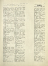
Rural Directory - Lots 9 and 10, Prince County
Description: A directory listing of residents of lots 9 and 10.
Publisher: Cummins Map Co.
Province: Prince Edward Island
Type: text
Date Issued (Source): 1927
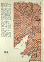
Lot 10: Prince County
Description: The map shows Lot 10 in Prince county. Shown are rivers, roads, landowners, and acreage.
Publisher: Cummins Map Co.
Province: Prince Edward Island
Type: cadastral maps
Date Issued (Source): 1927

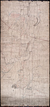
Plan of Lot Ten: Prince Co., P.E.I.
Description: The map shows lot 10 in Prince county. Shown are roads, rivers and creeks, railroad and station, post offices, a school, and landowners and acreage. Compass.
Publisher: J. H. Meacham & company
Province: Prince Edward Island
Type: cadastral maps
Date Issued (Source): 1880