IslandImagined
Historic Maps of PEI
Menu
Main navigation
Search
Map Archive
Map Archive sub-navigation
All Maps
... by County
Prince
Queens
Kings
... by Type
Boundary Maps
Cadastral Maps
Chorographic Maps
Fire Insurance Maps
Historical Atlases
Plans
Topographic Maps
Atlases
Cummins Atlas - 1928
Roe Brothers Atlas - 1878
Meacham's Atlas - 1880
Interactive
Interactive sub-navigation
Map Timeline
GeoPEI Map Viewer
Learn More
Learn More sub-navigation
FAQ
Learning Guides
Articles
Online Books
Glossary
Contact
Breadcrumb
Home
Search Content
Displaying 1 - 1 of 1
Results per page
27
54
108
Sort
Relevance ā
Relevance ā
Title ā
Title ā
Year ā
Year ā
Displaying 1 - 1 of 1
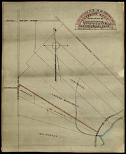
Plan of Proposed Road on A. Dickerson's Farm Township No. 23: Surveyed by John P. Nicholson Pā¦
Description:
Plan of proposed road on A. Dickerson's Farm on Lot 23. (No.53). The plan shows a proposed new road, coloured orange, through Arthur Dickerson's farm between Rennie Road and St. Mary'sā¦
more
Province:
Prince Edward Island
Type:
engineering maps