Displaying 1 - 14 of 14

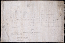
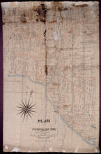
Plan of Township No. 67, and its environs.: Compiled from Surveys by Geo. Wright; H.J. Cundall;…
Description: Plan of Lot 67 and its environs. Compiled from surveys by Geo. Wright, H.J. Cundall, Joseph Ball, and Owen Curtis. Drawn by Thomas MacKinlay. Shows names of some residents, roads, railroads, bodies… more
Province: Prince Edward Island
Type: cadastral maps
Date Created: 1877-08-01
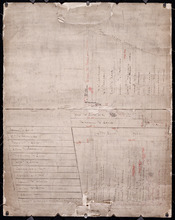
A Plan of the Property of Capt. Simon and Alexander Cheverie: in Souris East
Description: A plan of the property of Capt. Simon and Alexander Cheverie in Souris East. The map shows lots, acreage, roads/streets, and buildings.
Province: Prince Edward Island
Type: cadastral maps
Date Created: 1879-06-18

A Plan of Township No 4 Part of the Cunard Estate Prince County P.E.Island
Description: A plan of Lot 4, part of the Cunard Estate. Copied from plans in the Public Lands Department. The map shows lots, residents, bodies of water such as rivers, railways, and roads.
Province: Prince Edward Island
Type: cadastral maps
Date Created: 1885-06

Plan of Cascumpec Point Copied from a Plan in the Public Lands Departt. furnished by John Ball. L.…
Description: Plan of Cascumpec Point, Lot 5. The map shows numbered parcels of land on Cascumpec Point with names of residents and some land conveyance references. The legend indicates that parcels are outlined… more
Province: Prince Edward Island
Type: cadastral maps
Date Created: 1885-06
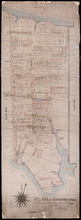
Plan of part of Lot 50
Description: Plan of part of Lot 50 (No.13). Area east of the Murray Harbour Road, north of the Dundee Road, and south of Georgetown Road. Shows names of residents.
Province: Prince Edward Island
Type: cadastral maps

Plan of Township Number 49. Shewing "Cunard" portion borderd. yellow. "Loan Act…
Description: Plan of Lot 49 showing Cunard portion bordered yellow, Loan Act Land bordered green, and remainder of Township (No.134). Copied from Meacham's Atlas by Owen Curtis. Shows names of residents,… more
Province: Prince Edward Island
Type: cadastral maps
Date Created: 1883-08
Plan of Township No. 44. Corrected from Surveys by Owen Curtis, J. C. Underhay and others. By Thos…
Description: Plan of Lot 44 (No.118) corrected by Thomas MacKinlay from surveys by Owen Curtis, J.C. Underhay and others. Cunard Estate. Shows some residents' names, acreage, and land conveyance references,… more
Province: Prince Edward Island
Type: cadastral maps
Date Created: 1887-09
Plan of Lot 32 (No.86).: Cunard Estate.
Description: Plan of Lot 32 (No.86). Cunard Estate. Shows names of residents, acreage, and some land conveyance references, bodies of water such as creeks and rivers, and roads. Copied by Owen Curtis.
Province: Prince Edward Island
Type: cadastral maps
Date Created: 1876-07
Plan of Township No. 9: Copied from plan furnished by Proprietress with alterations and additions…
Description: Plan of Lot 9 (No.26). Sullivan Estate. Copied from plan furnished by Proprietress with alterations and additions from surveys by Owen Curtis, John Clay &c. Shows names of residents, acreage, and… more
Province: Prince Edward Island
Type: cadastral maps
Date Created: 1883-08-18

Plan of Township No. 13: From a Survey by Alex Anderson Copied from a Plan made by John Clay…
Description: Plan of Lot 13 - Yeo Estate.
Province: Prince Edward Island
Type: cadastral maps
Date Created: 1878

Plan of Lot or Township No. 40: From latest Surveys by Joseph Ball and Owen Curtis, Land Surveyors.
Description: Plan of Lot 40 (No.109). Worrell Estate.
Province: Prince Edward Island
Type: cadastral maps
Plan of the Fane Melville and Selkirk Estates on Township No. 53: By Owen Curtis LS
Description: Plan of the Fane, Melville, and Selkirk Estates on Lot 53 (No.142). Unfinished plan. Shows names, acreage, and land conveyance references for some residents. The map also shows roads such as… more
Province: Prince Edward Island
Type: cadastral maps
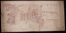
A Plan of Glenaladale, The property of the Heirs of the late Honbl. Donald McDonald
Description: Plan of part of Lot 36 (No.98), Glenaladale, the property of the Heirs of the late Hon. Donald McDonald. Shows names of residents, acreage, and a few land conveyance references, bodies of water such… more
Province: Prince Edward Island
Type: cadastral maps
Date Created: 1856
Plan Shewing the division of Pasture Lots Nos. 61, 62, 70 & 71 in the Royalty of Charlotte Town
Description: Plan showing the division of Pasture or Royalty Lots No.61, No.62, No.70 and No.71 in the Royalty of Charlottetown.
Province: Prince Edward Island