Displaying 1 - 1 of 1
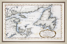
Carte du Golphe de St. Laurent et Pays Voisins Pour Servir a l'Histoire Generale des Voyages.
Description: The map shows the Gulf of St. Lawrence, New Brunswick, Newfoundland, Prince Edward Island, and parts of Nova Scotia and Quebec. It shows Anticosti Island and the Magdelan Islands. The map uses labels… more, Provenance: Purchased by Mr. Macnutt in London at the Map House in 1982. [Information from the back of the item], Exhibition & Catalogue: 1. The James W. Macnutt Collection of Maps of the Gulf of St. Lawrence with Particular Emphasis on Prince Edward Island, Confederation Centre Art Gallery and Museum, June… more
Province: New Brunswick, Newfoundland, Nova Scotia, Prince Edward Island, Quebec
Type: topographic maps