IslandImagined
Historic Maps of PEI
Menu
Main navigation
Search
Map Archive
Map Archive sub-navigation
All Maps
... by County
Prince
Queens
Kings
... by Type
Boundary Maps
Cadastral Maps
Chorographic Maps
Fire Insurance Maps
Historical Atlases
Plans
Topographic Maps
Atlases
Cummins Atlas - 1928
Roe Brothers Atlas - 1878
Meacham's Atlas - 1880
Interactive
Interactive sub-navigation
Map Timeline
GeoPEI Map Viewer
Learn More
Learn More sub-navigation
FAQ
Learning Guides
Articles
Online Books
Glossary
Contact
Breadcrumb
Home
Search Content
Displaying 1 - 1 of 1
Results per page
27
54
108
Sort
Relevance β
Relevance β
Title β
Title β
Year β
Year β
Displaying 1 - 1 of 1
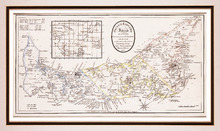
Prince Edward Island, divided into Counties & Parishes, with the Lots, as Granted by Governmentβ¦
Description:
Framed map of the province of Prince Edward Island. As the title indicates, the map shows Prince Edward Island divided into counties (shown in blue, yellow and pink), parishes and the Holland lots.β¦
more
Publisher:
Ashby, H.
Province:
Prince Edward Island
Type:
topographic maps
Date Created:
1798