Displaying 1 - 15 of 15
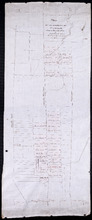
Plan "B" part of Township No. 33. as divided amongst the Children of the late Alfred…
Description: Plan of part of Lot 33 as divided amongst the children of the late Alfred Winsloe. Plan B. (No.87). The map also shows Rustico and Covhead Bays, along with Brackley Point, Union, Malpeque, and… more
Province: Prince Edward Island
Type: cadastral maps
Date Created: 1872-06-11
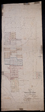
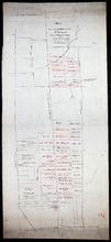
Plan of Township No. 33 In Prince Edward Island. Part of the Estate of the late John Hodges Winslow…
Description: Plan of Lot 33 (No.88). Part of the estate of the late John Hodges Winslow. Copied from the Original Plan by Thos. MacKinlay, April 23, 1847. Shows names of residents, acreage, and land conveyance… more
Province: Prince Edward Island
Type: cadastral maps
Date Created: 1847-04-23
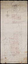
Plan of the Property of Mrs Smith situate in Township No 33 in Prince Edward Island: Mrs S's…
Description: Plan of part of Lot 33 showing the property of Mrs. S.W. Smith. The map shows lots, residents, acreage, roads, and water.
Province: Prince Edward Island
Type: cadastral maps
Plan of the Property of Ms S W Smith Situate on Township No 33 in Prince Edward Island: Mrs S'…
Description: Plan of part of Lot 33, showing the property of Mrs. S.W. Smith. The map shows lots, residents, roads, and bodies of water such as rivers.
Province: Prince Edward Island
Type: cadastral maps
Royalty of Charlotettown
Description: Plan showing the line dividing Lots 33 and 34. (No.10). The map shows lots, residents, roads, and bodies of water.
Province: Prince Edward Island
Type: cadastral maps
Plan of proposed road from Winsloe Road to Brackley Point Road touching at Roy; Junc; Station
Description: Plan of proposed road from Winsloe Road to Brackley Point Road touching at Royalty Junction Station. Lot 33. (No.28) The map shows lots, roads, and residents.
Province: Prince Edward Island
Type: cadastral maps

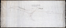
Plan Shewing the position of the Northern points of Commencement of the Lines dividing Lots 33 and…
Description: The map shows northern portions of Lots 24, 33, 34 and 35 along the north shore of Prince Edward Island. It shows the northern-most sections of three boundary lines: the line dividing Lots 24 and 33… more
Province: Prince Edward Island
Type: chorographic maps
Date Created: 1835-05-07

Plan of Township No. 33 in Prince Edward Island: Part of the Estate of John Hodges Winsloe Esq.…
Description: Plan of Lot 33. Winsloe Estate.
Province: Prince Edward Island
Type: cadastral maps
Date Created: 1834-09-20
Plan of the property of Mrs. S.W. Smith situated on Township No. 33 in Prince Edward Island
Description: Plan of part of Lot 33. The property of Mrs S.W. Smith. The map shows Winter River, and roads (Brackley Point), (Union), and a compass.
Province: Prince Edward Island
Type: cadastral maps
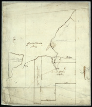
Part of Lot 33: Area around Rustico Bay
Description: Plan of part of Lot 33. Area around Rustico Bay. The map shows the area around Rustico Bay in the northwest part of Lot 33. It shows the land divided into parcels with names of some residents and… more
Province: Prince Edward Island
Type: cadastral maps
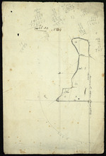
Parts of Lot 33: Two maps showing the northern extremities of the east and west boundaries of Lot 33
Description: Plans of two parts of Lot 33 (No.4): McMillan's Point; Grand Pere Point. This item consists of 2 maps on one sheet--one each on the front and back. Side One shows McMillan Point on Covehead Bay… more
Province: Prince Edward Island
Type: boundary maps
Rural Directory - Lots 31 - 34, Queens County
Description: A directory listing of residents of lots 31, 32, 33, and 34.
Publisher: Cummins Map Co.
Province: Prince Edward Island
Type: text
Date Issued (Source): 1927
Rural Directory - Lots 33 and 34, Queens County
Description: A directory listing of residents of lots 33 and 34.
Publisher: Cummins Map Co.
Province: Prince Edward Island
Type: text
Date Issued (Source): 1927
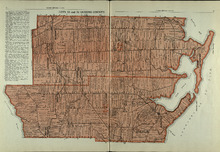
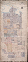
Lots 33 and 34 : Queens County
Description: The map shows lots 33 and 34 in Queens county. Shown are the Gulf of St. Lawrence, Cove Head and Rustico Bay, Hillsborough River, landowners, acreage, roads, railroads, Royalty Junction and Suffolk… more
Publisher: Cummins Map Co.
Province: Prince Edward Island
Type: cadastral maps
Date Issued (Source): 1927
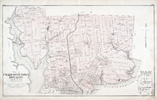
Plan of Charlottetown Royalty: Queens Co., P.E.I.
Description: The map shows the city of Charlottetown and a plan for lots. Shown are rivers, creeks, roads, railroad and stations, landowners and acreage, mills, park, bridge, college, farms, asylums, and a… more
Publisher: J. H. Meacham & company
Province: Prince Edward Island
Type: cadastral maps
Date Issued (Source): 1880