Displaying 1 - 2 of 2
Section Shewing the Elevations of the Prince Toen Road from Hunter River to the Junction Road.
Description: Plan showing the elevations of the Prince Town Road from Hunter River to the Junction Road.
Province: Prince Edward Island
Type: cadastral maps
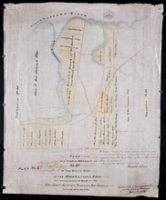
Plan of a Part of Township No. 35 on the South Side of the Hillsborough River: Those portions…
Description: Plan of part of Lot 35 on the south side of the Hillsborough River showing the property of Rev. John Alister Somerlet MacDonald. Copied from a tracing by W.C. Harris in the Land Office (Plan No.3).… more
Province: Prince Edward Island
Type: cadastral maps
Date Created: 1878