Displaying 1 - 2 of 2
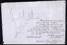
Plan of the division line between Lots 59 and 61, surveyed under the provisions of the Boundary…
Description: Plan of the division line between Lots 59 and 61, surveyed under the provisions of the Boundary Bill 4 William 4 Cap.15. This copy is taken from an original plan created 15 August 1838 by surveyor… more
Province: Prince Edward Island
Type: cadastral maps
Date Created: 1838-08-15
Date Modified: 1908-02
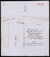
Plan of part of the Georgetown Road on Lot 51 showing the encrouchment by John Curran from a survey…
Description: Plan of part of the Georgetown Road on Lot 51. Shows Union Road and property of John Curran. (No.3) The map shows lots, resident, and roads.
Province: Prince Edward Island
Type: cadastral maps
Date Created: 1908-06-04