Displaying 1 - 3 of 3

Plan de l'Ȋle de St. Jean au Nord de l'Acadie et dans le Sud du Golfe de St. Laurent.:…
Description: Plan de l'Ȋle de St. Jean. Par Ordre de M. de Sartine, Conseiller d'Etat, Ministre et Secretaire d'Etat au Département de la Marine. The map shows the province of Prince Edward Island… more
Publisher: Sartine, M. de
Province: Prince Edward Island
Type: topographic maps
Date Created: 1778
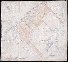
Plan of Lots 38, 39, 40, 41, 42, 66 and part of Lot 43
Description: The map shows some of the lots and parishes in a northern portion of Kings County. It shows Savage Harbour, St. Peter's Bay, rivers, streams, mills, roads, buildings and churches. The map has a… more
Province: Prince Edward Island
Type: topographic maps

Map of Prince Edward Island in the Gulf of St. Lawrence: for McGregor's British America
Publisher: Ballantyne and Company
Province: Prince Edward Island
Type: cadastral maps, topographic maps
Date Created: 1832