Displaying 1 - 2 of 2

Prince Edward Island Nova Scotia and New Brunswick: Prince, Queens and Kings Counties, P.E.I.…
Description: Prince, Queens and Kings Counties, Prince Edward Island, portions of New Brunswick, Nova Scotia, and Magdalen Islands. It marks counties, parishes, cities, towns, and villages, beaches, marshes, Lots… more
Publisher: Hydrographic and Map Service, Labelle Building
Province: Prince Edward Island, Nova Scotia, New Brunswick, Quebec
Type: cadastral maps
Date Created: 1940
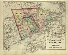
Counties of Westmoreland and Albert: New Brunswick
Description: The map shows the counties of Westmoreland and Albert in New Brunswick. Shown are bays, Cumberland basin. railroads and stations, roads, cities and towns.
Publisher: Roe Brothers
Province: New Brunswick
Type: geological maps
Date Issued (Source): 1878