Displaying 1 - 2 of 2

Plan of Lot Seventeen: Prince Co., P.E.I.
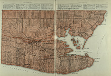
Description: The map shows lot 17 along with two smaller maps of lot 17 and 23. The map includes landowners and acreage, railroads and stations, roads, districts, creeks, rivers, bays, marshes, brooks, coves,… more
Publisher: J. H. Meacham & company
Province: Prince Edward Island
Type: cadastral maps
Date Issued (Source): 1880
Lots 63 and 64: Kings County
Description: The map shows lots 63 and 64 in Kings county. Shown are Northumberland Strait, Gulf of St. Lawrence, Murray Harbour, Island and River, points, Herring Ponds, landowners, acreage, roads, and railroads.
Publisher: Cummins Map Co.
Province: Prince Edward Island
Type: cadastral maps
Date Issued (Source): 1927