Displaying 1 - 4 of 4
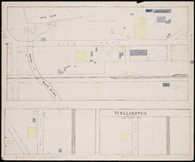
Wellington, Lot 16
Description: This item is a fire insurance plan of the community of Wellington. It shows the village in three (3) sections that are intended to be continuous. The largest map section, across the top of the sheet… more
Province: Prince Edward Island
Type: fire insurance maps
Date Issued (Source): 1888
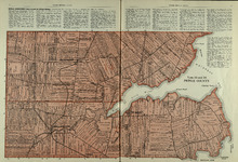
Lots 14 and 16 : Prince County
Description: The map shows lots 14 and 16, in Prince county. Shown are bays, ponds, coves, landowners, acreage, rivers, and roads.
Publisher: Cummins Map Co.
Province: Prince Edward Island
Type: cadastral maps
Date Issued (Source): 1927

Plan of Lot Fourteen & Sixteen : Prince Co., P.E.I.
Description: Map shows lots fourteen & sixteen in Prince county. Shown are roads, creeks, coves, rivers, post offices, railroads and stations, ferries, points, bays, landowners, acreage, churches, and… more
Publisher: J. H. Meacham & company
Province: Prince Edward Island
Type: cadastral maps
Date Issued (Source): 1880

Plan of Lot Twenty Seven: Prince Co., P.E.I.
Description: The map shows lot 27 in Prince county. The map shows roads, railroads, crosses, ponds, rivers, bays, straits, coves, mills, post offices, and churhces. Graphic compass.
Publisher: J. H. Meacham & company
Province: Prince Edward Island
Type: cadastral maps
Date Issued (Source): 1880