IslandImagined
Historic Maps of PEI
Menu
Main navigation
Search
Map Archive
Map Archive sub-navigation
All Maps
... by County
Prince
Queens
Kings
... by Type
Boundary Maps
Cadastral Maps
Chorographic Maps
Fire Insurance Maps
Historical Atlases
Plans
Topographic Maps
Atlases
Cummins Atlas - 1928
Roe Brothers Atlas - 1878
Meacham's Atlas - 1880
Interactive
Interactive sub-navigation
Map Timeline
GeoPEI Map Viewer
Learn More
Learn More sub-navigation
FAQ
Learning Guides
Articles
Online Books
Glossary
Contact
Breadcrumb
Home
Search Content
Displaying 1 - 1 of 1
Results per page
27
54
108
Sort
Relevance β
Relevance β
Title β
Title β
Year β
Year β
Displaying 1 - 1 of 1
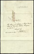
Plan Showing the Situation of Joseph Hammil's Farm on Lot No. 2. Containing Thirty acres onβ¦
Description:
Plan of part of Lot 2 showing Joseph Hammill's Farm containing 30 acres. The map shows Joseph Hammill's 30-acre parcel shaded in a greenish colour. It also shows the adjacent parcel of Johnβ¦
more
Province:
PE
Type:
cadastral maps