IslandImagined
Historic Maps of PEI
Menu
Main navigation
Search
Map Archive
Map Archive sub-navigation
All Maps
... by County
Prince
Queens
Kings
... by Type
Boundary Maps
Cadastral Maps
Chorographic Maps
Fire Insurance Maps
Historical Atlases
Plans
Topographic Maps
Atlases
Cummins Atlas - 1928
Roe Brothers Atlas - 1878
Meacham's Atlas - 1880
Interactive
Interactive sub-navigation
Map Timeline
GeoPEI Map Viewer
Learn More
Learn More sub-navigation
FAQ
Learning Guides
Articles
Online Books
Glossary
Contact
Breadcrumb
Home
Search Content
Displaying 1 - 1 of 1
Results per page
27
54
108
Sort
Relevance β
Relevance β
Title β
Title β
Year β
Year β
Displaying 1 - 1 of 1
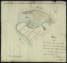
Plan of A tract of Land the property the Messrs. Macmillans & Peter Higgins on Township No. 34β¦
Description:
Plan of part of Lot 34 (No. 182). The map shows a parcel of land 111 acres in size belonging to Angus MacMillan, Peter Higgins and Alexander MacMillan near the entrance to Covehead Harbour and whatβ¦
more
Province:
Prince Edward Island
Type:
cadastral maps
Date Created:
1854