Displaying 1 - 3 of 3
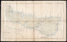
Plan of Île Saint-Jean: The Island of Saint John
Description: Plan of Ile Saint-Jean / the Island of Saint John. The map shows Prince Edward Island and a portion of the mainland. It identifies settlements, bays, harbours, rivers and islands. Sandy areas are… more
Province: Prince Edward Island
Type: topographic maps
Date Created: 1760

Plan of Lot or Township No. 41: From The Latest Surveys By Joseph Ball S.G., Copied by O. Curtis
Description: Plan of Lot 41 (No.111). Showing residents. Surveyed by Joseph Ball. Plan copied by Owen Curtis.
Province: Prince Edward Island
Type: cadastral maps
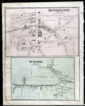
Kensington, Lot 19: St. Peters, Lot 41
Description: The map shows lot 19 in Kensington. Shown are a school house, a hall, roads, landowners, railroad and depot grounds, businesses and churches. Compass.
Publisher: J. H. Meacham & company
Province: Prince Edward Island
Type: cadastral maps
Date Issued (Source): 1880