Displaying 1 - 2 of 2
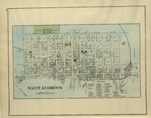
St. Andrews
Description: The map of St. Andrews. Shown are a Reference table, railroads and station, military lands, roads, lots, owners, and wharfs.
Publisher: Roe Brothers
Province: New Brunswick
Type: geographical maps
Date Issued (Source): 1878

Plan of Lot Thirty Seven : Plan of Lot Thirty Eight: Queens Co., P.E.I.. Kings Co., P.E.I.
Description: The map shows lot 37 (coloured in pink) in Queens county, and lot 38 (coloured in blue) in Kings county. Shown are roads, railroads, landowners and acreage, rivers, ponds, harbours, gulfs, creeks,… more
Publisher: J. H. Meacham & company
Province: Prince Edward Island
Type: cadastral maps
Date Issued (Source): 1880