Displaying 1 - 4 of 4
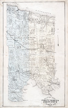
Plan of Lots Fourty Three & Fourty Four: Kings Co., P.E.I.
Description: The map shows lots 43 & 44 in Kings county. Shown are bays, gulfs, rivers, coves, capes, roads, railroads and stations, landowners and acreage, crosses, post offices, churches, and factories.… more
Publisher: J. H. Meacham & company
Province: Prince Edward Island
Type: cadastral maps
Date Issued (Source): 1880
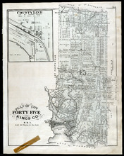
Plan of Lot Fourty Five: Kings Co., P.E.I.
Description: The map shows Lot 45 in Kings county. Shown are the gulf, bay, rivers, coves, post offices, cross, mills, roads, railroad, landowners and acreage, churches, hospital, harbour, and sand. Compass.
Publisher: J. H. Meacham & company
Province: Prince Edward Island
Type: cadastral maps
Date Issued (Source): 1880
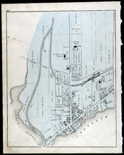
Souris
Description: The map shows a part of Souris. Shown are the Souris river, sand beach, roads, railroads, churhces, landowners, houses, buildings and businesses. Compass
Publisher: J. H. Meacham & company
Province: Prince Edward Island
Type: cadastral maps
Date Issued (Source): 1880
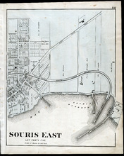
Souris East: Lot Forty Five
Description: The map shows Lot 45 in Souris East. Shown are the Souris Harbour and Bay, wharfs, roads and streets, railroads, lobster factory, landowners, houses, buildings and businesses. Compass
Publisher: J. H. Meacham & company
Province: Prince Edward Island
Type: cadastral maps
Date Issued (Source): 1880