IslandImagined
Historic Maps of PEI
Menu
Main navigation
Search
Map Archive
Map Archive sub-navigation
All Maps
... by County
Prince
Queens
Kings
... by Type
Boundary Maps
Cadastral Maps
Chorographic Maps
Fire Insurance Maps
Historical Atlases
Plans
Topographic Maps
Atlases
Cummins Atlas - 1928
Roe Brothers Atlas - 1878
Meacham's Atlas - 1880
Interactive
Interactive sub-navigation
Map Timeline
GeoPEI Map Viewer
Learn More
Learn More sub-navigation
FAQ
Learning Guides
Articles
Online Books
Glossary
Contact
Breadcrumb
Home
Search Content
Displaying 1 - 1 of 1
Results per page
27
54
108
Sort
Relevance ↓
Relevance ↑
Title ↓
Title ↑
Year ↓
Year ↑
Displaying 1 - 1 of 1
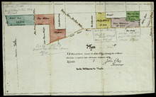
Plan of 75 Acres of land leased to John Clay, showing the different divisions in which it was…
Description:
Plan of part of Lot 26. The plan shows 75 acres of land in the western part of Lot 26 leased to John Clay and then later divided and conveyed to other individuals. The plan shows names of residents…
more
Province:
Prince Edward Island
Type:
cadastral maps
Date Created:
1878-08-05