Displaying 1 - 4 of 4
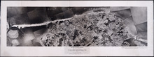
Prince Edward Island National Park: New London - Rustico Section 1937
Description: Prince Edward Island National Park, New London - Rustico section, Lots 22, 23 and 24. Aerial photograph. Department of Mines and Resources, Mines and Geology Branch, Bureau of Geology and Topography.
Province: Prince Edward Island
Type: cadastral maps
Date Created: 1937
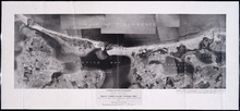
Prince Edward Island National Park: Rustico Island and Brackley Beach Sections
Description: Prince Edward Island National Park. Rustico Island and Brackley Beach sections. Lots 24, 33 and 34. Department of Mines and Resources, Mines and Geology Branch, Bureau of Geology and Topography.
Province: Prince Edward Island
Type: cadastral maps, geological maps
Date Created: 1937
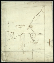
Part of Lot 33: Area around Rustico Bay
Description: Plan of part of Lot 33. Area around Rustico Bay. The map shows the area around Rustico Bay in the northwest part of Lot 33. It shows the land divided into parcels with names of some residents and… more
Province: Prince Edward Island
Type: cadastral maps
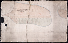
Plan Shewing the situation of the respective Fishing Establishments, Fronting Harris or Rustico Bay…
Description: Plan of part of Lot 24. Shows situation of the fishing establishments fronting Harris or Rustico Bay. From actual survey. The map shows the Harbours Mouth and Robinsons Island.
Province: Prince Edward Island
Type: cadastral maps
Date Created: 1869-09-02